
RECREATION
La Verkin Overlook Trail to City Monument
Acivities: Hiking, Photography / La Verkin Overlook Trail map
The trailhead is located at approximately 400 South & 100 West. There is a small gravel parking lot and trailhead sign. This is located in a neighborhood, please respect the privacy and do not litter. The trail winds up the face with a few steep sections and then reaches the top to follow north along a ridgeline overlooking the city and the Virgin River Gorge to the east. It ends at the La Verkin Overlook Monument view area. The trail is approximately 1.1 miles one way.
The monument can also be accessed by passenger vehicle from Highway 9 and the La Verkin Overlook Road to the north (on the way to Zion National Park). The road is dirt/gravel and approximately 1.5 miles. This is also a beautiful area for photograpy of the La Verkin valley with the Pine Valley Mountains to the west and Zion National Park to the east.
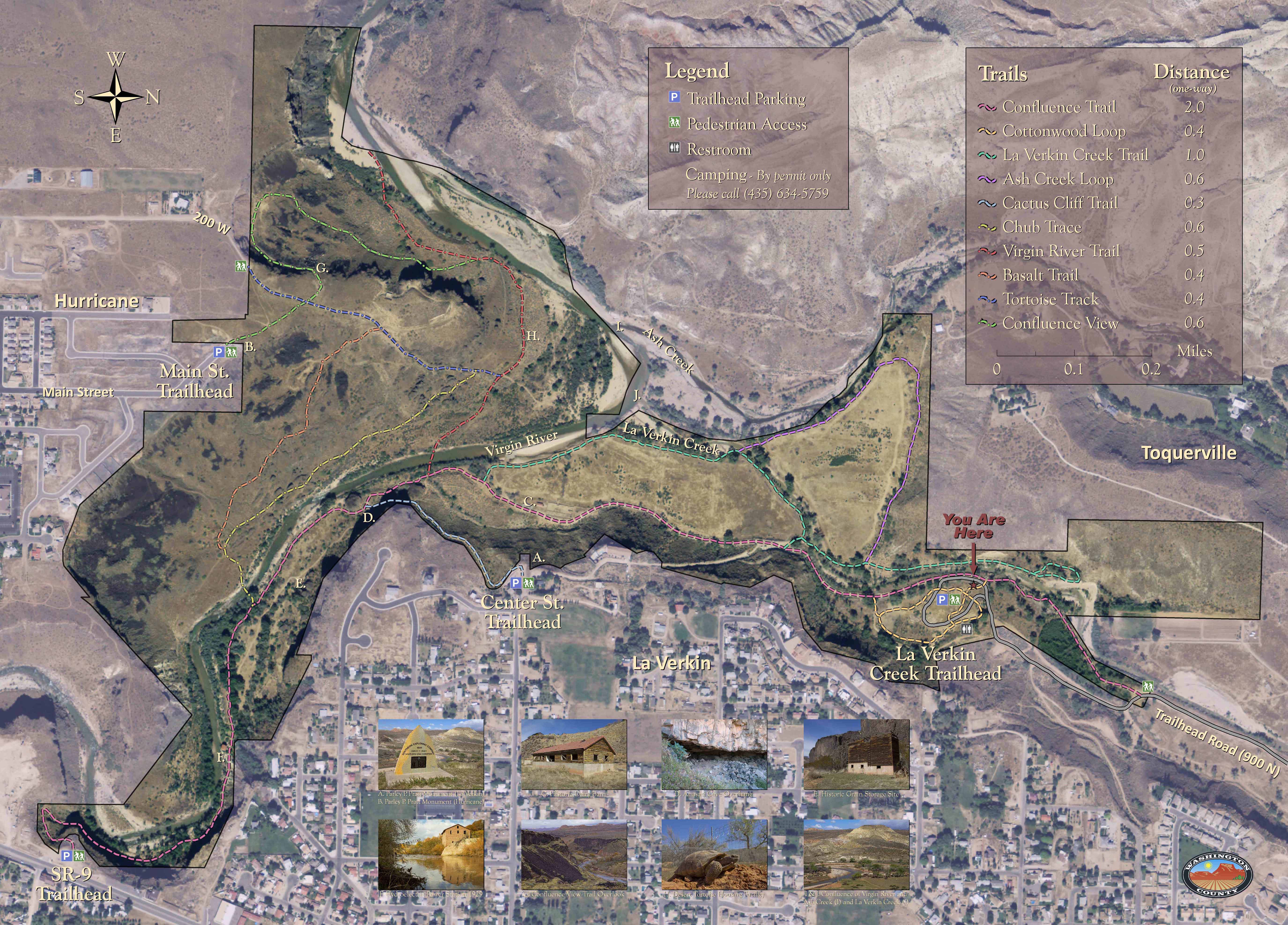
Confluence Park, La Verkin
Activities: Hiking, Mountain Biking, Picnics, Photography / Confluence Park Trails Map
Confluence Park is a beautiful nature park where the Virgin River, Ash Creek and La Verkin Creek converge. Surrounded by cliffs or hills it offers a serene valley to enjoy hiking, casual trail biking and picnicing under giant Cottonwood trees. There are three trailheads in La Verkin and one in Hurricane, all with easy access. Confluence Park is very dear to La Verkin as many residents enjoyed it long before it became a park. This is a great place for everyone to enjoy nature and get in some hikes when you have only a few hours or more. Sunset in the park offers great photographic opportunities. Don't miss the Desert Toroise Rehabilitation area accessed from the Hurricane Trailhead. There are plans in the future for another trailhead and continual work to keep native plants, Desert Tortoises and fish thriving. Restrooms are at the 900 North entrance and the south trailhead in Hurricane. Confluence Park is part of the Red Cliffs Desert Reserve.
Red Cliffs Desert Reserve
Activities: Hiking, Mountain Biking / Red Cliffs Desert Reserve website
Free visitor center of the Red Cliffs Desert Reserve, located at 10 North, 100 East in St. George, Utah,
Established in 1996 the Red Cliffs Desert Reserve is a 62,000-acre scenic wildlife reserve set aside to protect the Mojave Desert Tortoise and other rare and sensitive plants and animals. At the junction of three great ecosystems, the Mojave Desert, the Great Basin, and the Colorado Plateau, the Reserve covers an area of approximately 20 miles wide and 6 miles deep. Thanks to the courage and foresight of the Washington County leadership the Red Cliffs Desert Reserve is one of the largest regional reserves in the country.
In 2009 Congress designated it as the Red Cliffs National Conservation Area (NCA) under the Omnibus Public Land Management Act of 2009. The new NCA is managed by the BLM St. George Field Office.
Red Cliffs Trails and Trailheads
Other nearby attractions and recreation activities not to miss.
State Parks near La Verkin:
Quail Creek State Park - boating, fishing, camping, kayaking
Sand Hollow State Park - boating, fishing, camping, OHV recreation, kayaking
Snow Canyon State Park -hiking, biking, climbing
Gunlock State Park -boating, water sports and quality fishing
Coral Pink Sand Dunes State Park - OHV recreation, hiking
Kodachrome Basin State Park -hiking, photography
La Verkin has excellent access to numerous mountain biking sites in the area. For more information on mountain biking in the area visit the St. George BLM Field Office web site or:
Dixie Mountain Bike Trails Assoc


.jpg)
